Beinn Liath Mhòr Fannaich and Sgùrr Mòr; and Creagan a’Chaise
Beinn Liath Mhòr Fannaich and Sgùrr Mòr

A group of five set off for Beinn Liath Mhòr Fannaich and Sgùrr Mòr from the car park at Loch Droma dam following the hydro track and pipeline leading to Coir’ a’ Mhadaidh. The pipelines and dam were built in the 1950’s as part of the Conon Valley Hydro scheme to extend the Clascarnoch catchment westwards beyond the low lying watershed.After about two and half kilometres the track forks right to cross the Allt a’ Mhadaidh. We went left, having decided to tackle the hills clockwise as a result of a couple of bad experiences descending the boulders on the NW slopes of Beinn Liath Mhòr Fannaich. The snow from yesterday and overnight started to lie at about 600m, but was little more than a couple of centimetres. There was no wind and the temperature barely reached freezing on the summit of Beinn Liath Mhòr Fannaich although the cloud obscured the views. We sat about for bit until we began to feel the chill, so set off to pick up the stalkers path leading to Sgùrr Mòr. The cloud lifted and we had great views into the east face of Sgùrr Mòr and back along to the eastern summits of the Fannaich ridge.
By the time we reached the summit, the cloud had swirled in again and we set off down to the bealach with Càrn na Crìche. The descent was steepish over boulder strewn slopes covered with a slippery layer of fresh snow, so some careful foot placement was in order. Our target was the Am Burach bealach with Meall a’ Chrasgaidh which would give us an easy descent off the ridge. We knew that before we gained the path along Creag Raineach Mòr there would probably be an old snow patch with ice from the small burns that start there. For the first time we donned crampons.
The Creag Raineach Mòr path is not shown on OS maps, but provides a good route off with great views of Loch a’ Mhadaidh, the corrie and the crags above. Then heading for the usual path from the loch outlet shown on the OS map, I was disappointed to encounter the first of a series of muddy ATV tracks which had ploughed into the soft ground in recent years. The Dutch owned Foich and Inverlael Deer Forest encompasses this part of the Fannaich and separately, three of the Beinn Dearg Munros north of the “famine wall”.


Creagan a’Chaise
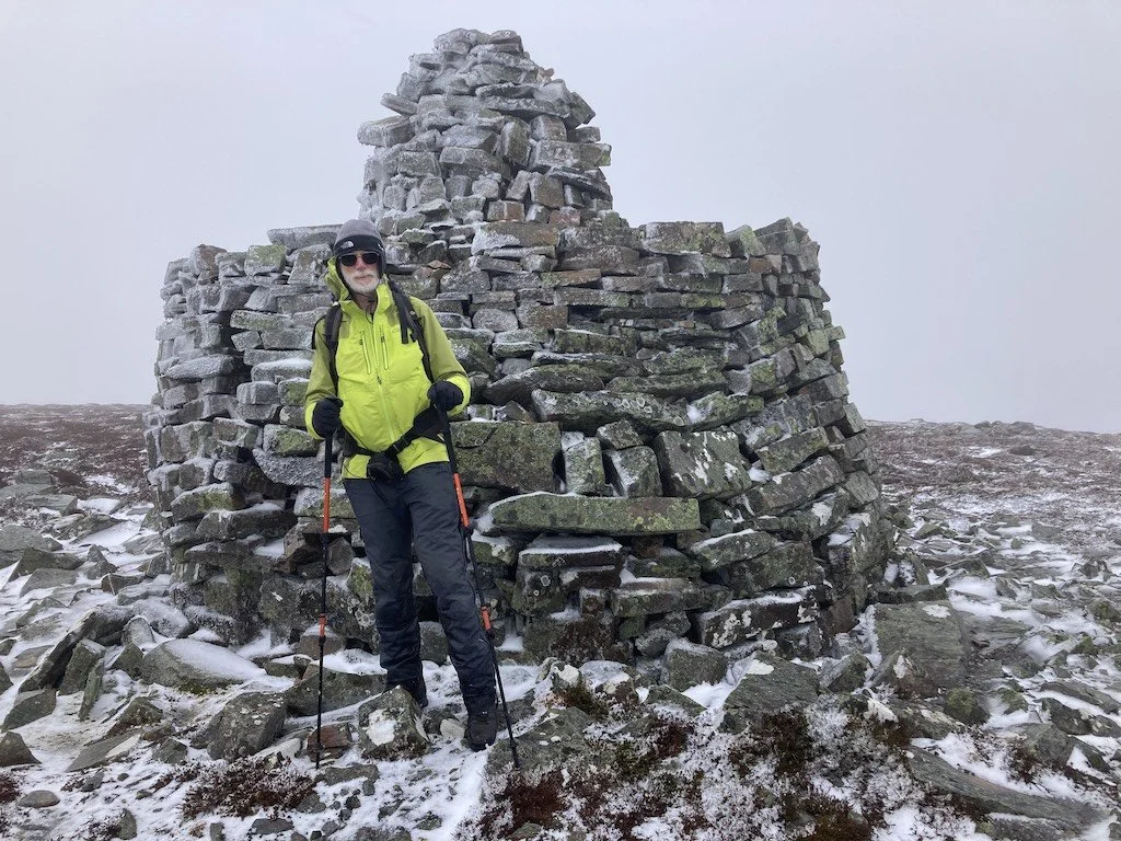
We set off on the track from the A939 south of Lynemore at NJ 064 232, where there isn't any parking. However, there is a loop of old road about 500m south on the right with oodles of space. There are a lot of tracks on the hill and more attention to map and whereabouts is necessary than we gave! So we found ourselves unexpectedly at Carn na Cloiche, which was on the planned way back. Although it wasn't actually misty, visibility was poor and it's low relief ground, so the compass was used in anger to navigate along the ridge, which is rather boggy, and thence to the final steeper pull up to the summit cairn of Creagan a'Chaise. The cairn celebrates the golden jubilee of Queen Victoria in 1887. We had a great view of nothing.
Although the weather wasn't as bad as the forecast, rime was accumulating on the windward side. No convenient stones for sitting on the lee side. Given the bogginess of the ridge and that it had started to snow with intent, we descended via the intended up route, which also starts boggy before becoming metalled. So we never got to Sgòr Gaoithe. Back to the car, and then on to tea and cake in Grantown-on-Spey.
Taking part: John and prospective member Andrew
Words: John
Photo: Andrew
Taking part: Matt, Emma, Stuart, Paul, Arthur
Words: Arthur
Photos: Paul and Arthur